Satellite Cal/Val
Satellite calibration/validation
A key activity supported by the Centre for Earth Observation is satellite calibration and validation, which underpins much of our remote sensing science, delivery of quality assured data for government applications, as well as our international cooperation activities. Calibration and validation (cal/val) activities form an integral component of the effective use of EO data and in the maintenance of the scientific value of EO data archives.
Calibration allows the traceability of satellite sensor data to physical standards, and provides a routine check on instrument performance. Earth observation satellite calibration data obtained in the Southern Hemisphere is sparse and in high demand. Validation establishes the link between EO measurements from space to derived data products and measurements on the ground, allowing for the verification of the algorithms, and models used to derive parameters and data products.
Successful implementation of cal/val activity needs careful planning of issues such as coordination of activities, selection of long-term, stable, scalable vicarious calibration sites, the need for documented standards, guidelines and traceability in cal/val measurements, the need for centralised calibration resources meeting multiple needs, tools to enable the organisation of supporting data and collection of associated metadata, and the continuation of such activities to meet the needs of future sensors.
CSIRO and other groups have recently teamed up with Geoscience Australia to undertake a validation of Digital Earth Australia (DEA) surface reflectance products. Using a set of well characterised sites around the country, field spectral measurements are being obtained coincident with satellite overpasses. The data are convoluted to satellite bands and can then be directly compared to the atmospherically collected satellite data. Analyses show a good fit between the two datasets for most sites. Good calibration of the instrumentation and reference panels used is important to ensure consistency.
CSIRO is currently developing an autonomous calibration site at the Pinnacles Desert approximately 200 km from Perth, Western Australia. Developed specifically for future spaceborne imaging spectroscopy sensors, this terrestrial vicarious calibration site is expected to also contribute to other multispectral optical medium spatial resolution (<30 m) sensors such as Landsat 8 and Sentinel2 operating across the visible to shortwave infrared spectral ranges. This site will be instrumented to acquire continuous radiometric (and BRDF) data as well as associated meteorological and atmospheric composition data contributing to international vicarious calibration efforts.
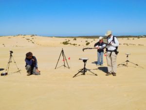
Satellite calibration using the Pinnacles site in Western Australia
Satellite calibration using the Pinnacles site in Western Australia
Other cal/val work being done at CSIRO includes:
- The aquatic optical cal/val site at Lucinda Jetty
- The altimetry cal/val work conducted by Oceans & Atmosphere
- The moisture sensor network (Cosmic Probe) conducted by Land & Water
- Validation sites such as Tumburumba which has multiple use including spaceborne lidar, fluorescence and optical