Research Activities
The Waterbird Research Project – one of the largest satellite tracking studies of birds in Australia.
A management challenge
In Australia and around the world, loss of wetland habitats is increasing and waterbird populations have declined. Australia has international and national obligations to protect waterbirds and their habitats. Increasing waterbird abundances and maintaining waterbird species diversity are explicit objectives of the Murray-Darling Basin Plan and its Environmental Watering Strategy.
There are many types of wetland sites that are associated with waterbirds:
- breeding sites – where waterbirds nest and raise their young;
- foraging sites – where waterbirds feed;
- stopover sites – where waterbirds rest and fuel up when moving between regions; and,
- refuge sites – where waterbirds go when other sites they usually visit are dry.
All of these types of wetland sites are managed through decisions affecting water, habitat and other pressures that are made by a range of agencies. To complicate things, many waterbird species are highly mobile and can move across jurisdictional boundaries.
In the context of climate change and competition for water resources, selection and prioritisation of sites for management requires information on ecological requirements, site use and connectivity for a range of waterbird species capable of moving from local to continental scales.
How our research helps
Our research aims to provide better understanding of the spatial and temporal scales and drivers of waterbird movements and site use. In turn, this knowledge informs adaptive management of water and wetlands to support waterbirds through their life cycles.
We use a range of approaches to meet this aim, including employing the latest technology in avian satellite transmitters (GPS trackers) to track the movements of waterbirds at local, area and Basin scales. We also use satellite data and associated products to undertake environmental analyses that incorporate weather and climate data and on-ground monitoring data from bird surveys and wildlife cameras.
Our research provides never-before-seen detail describing the spatial and temporal scales and drivers of waterbird movements and site use. In the Murray-Darling Basin and beyond we’ve identified important breeding, foraging, stopover, and refugia sites. This information assists with interpreting how site-scale waterbird responses to environmental watering measured through local monitoring are influenced by basin and national scale responses and drivers. It also provides new understanding of species movements and requirements to inform adaptive management actions and help explain waterbird response or lack of response to environmental watering.
To-date, we have tracked bird movements from multiple important waterbird breeding sites across the Murray-Darling Basin, including Barmah-Millewa Forest on the NSW-Victoria border, the Macquarie Marshes and Narran Lakes in northern NSW, the Booligal Wetlands, Lower Murrumbidgee and Lake Cowal in central and western NSW, and Kow Swamp and the Kerang Lakes in northern Victoria.
The main species tracked so far as part of our research include straw-necked ibis, royal spoonbills, Australian white ibis, great egret, and plumed egret (intermediate egret), however our team also has experience fitting transmitters to additional species, including Latham’s snipe, Australasian bittern, nankeen night heron, and musk duck.
We provide information about waterbird movements in:
- spatially and temporally explicit forms in real-time to inform immediate management at site scale (e.g. maps of where birds are breeding, maps of where breeding birds are going to get food for their chicks, and reports on physical condition of birds in breeding sites and environmental conditions on-ground); and
- summarised general forms based on statistical modelling across large numbers of birds and sites to guide longer-term planning.
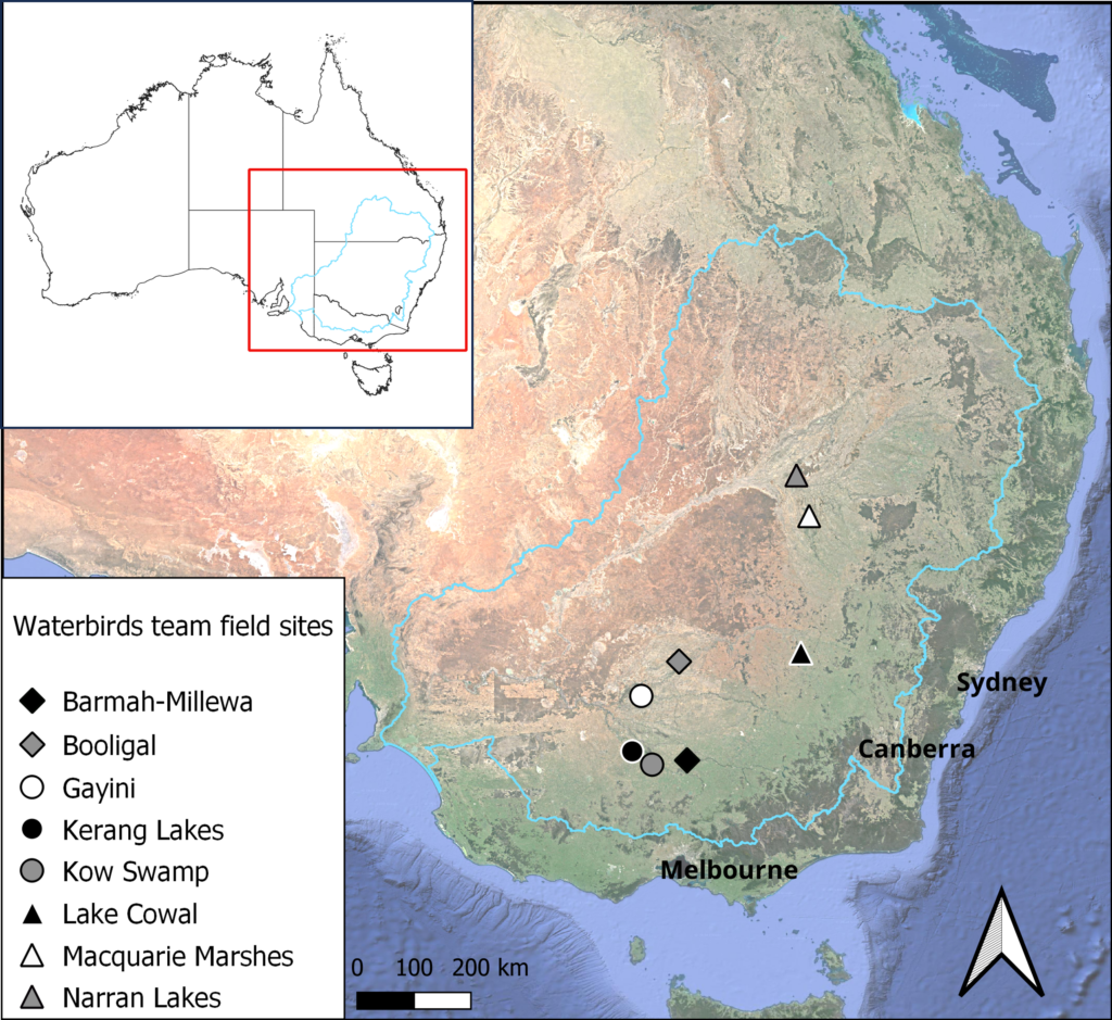
Satellite image showing the locations of our main field sites within the Murray Darling Basin. Blue outline shows the Murray Darling Basin.
Past and present research activities
Our waterbird movements research began in 2015-2016, with our first GPS satellite trackers deployed in October 2016 as part of the MDB EWKR (Murray-Darling Basin Environmental Watering and Knowledge Research) Project. You can read about key learnings from this period in the MBD EWKR Waterbirds Research Report.
Since then, we have deployed additional trackers in most years, expanding the range of sites and species with support from the CEWH Monitoring, Evaluation and Research program (Flow-MER) and other projects, and the Lake Cowal Conservation Centre.
This research program is now one of the largest satellite tracking studies of any bird species in Australia. We are hard at work analysing all the data and writing up the results!
Nested pages describe some of our core research themes and key learnings to-date, including:
- Waterbird movements
- Waterbird nesting
- Waterbird foraging
As well as learning more about the species we are already tracking we are also interested in the movements of many other waterbird species including brolga (Antigone rubicunda), musk duck (Biziura lobata), yellow-billed spoonbill (Platalea flavipes), glossy ibis (Plegadis falcinellus), magpie goose (Anseranas semipalmata), nankeen night-heron (Nycticorax caledonicus) and freckled duck (Stictonetta naevosa).
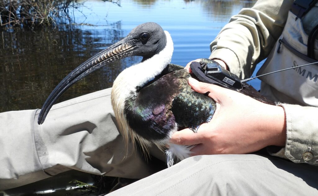
Adult straw-necked ibis with a satellite tracker. Image credit: CSIRO.
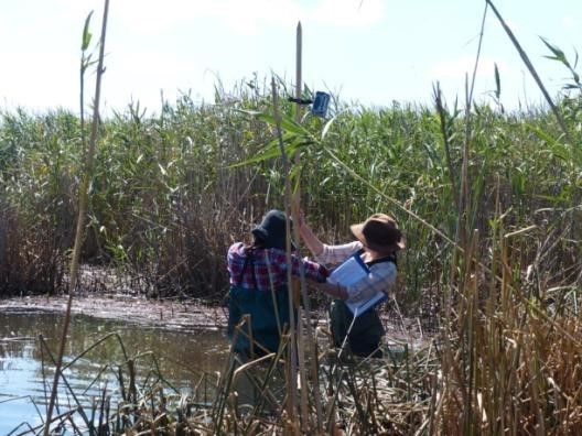
Setting up a camera within reed beds at the Barmah-Millewa Forest. Image credit: Heather McGinness