PaintCloud: Colourising 3D representations of the world based on lidar data
PaintCloud is a solution that enables the colourisation of otherwise colourless 3D representations of the world based on lidar data.
It allows mobile 3D mapping and surveying businesses to add colour to their accurate geometric maps without needing to upgrade their expensive 3D mapping equipment by simply attaching an arbitrary camera (e.g. a GoPro) to their existing equipment and PaintCloud’s state-of-the-art algorithms are able to augment geometry with colour.
3D point clouds from lidar devices are generally capable of conveying amazing structural information based on range. However, the lidar measurements used in the point clouds do not incorporate the colour of the surfaces hit by the lidar signal.
This is where PaintCloud serves as a powerful tool: it links the 3D range information from the lidar with the real-world colours captured by a camera, enabling users to extract more value from a 3D map.
Consider a 3D+PaintCloud scan of a commercial building under construction. What colour paint is used in the main office? Has grass been laid at the building entrance? What does the tile pattern look like in the lobby? Users can see the answers to these questions by simply navigating within a 3D map augmented with colour.
This enriched representation is paramount for the understanding of point clouds in a number of application scenarios, including mining, construction, manufacturing, surveying, agriculture and heritage building analysis.
The camera can be independent from the lidar scanner (e.g., any action camera can be used without clock synchronisation to the system) and PaintCloud ensures that the data from both modalities are synchronised coherently in time and registered coherently in space.
The loose coupling of the lidar and camera sensors imposes a number of challenges related to timing, point visibility and colour etermination. PaintCloud addresses each of these problems using multiple novel techniques in data fusion and 3D geometry.
-
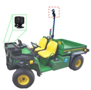
Camera positioning in an autonomous ground vehicle. - Contrary to typical approaches to augmenting geometry with colour where the camera is placed as close as possible to the lidar, allowing the assumption that the objects seen by the camera are the same as the objects seen by the lidar, PaintCloud’s state-of-the-art algorithms require no such constraint.
- Users have the freedom to position the camera anywhere on the platform.
- The ability to attach the camera to existing mapping hardware provides an opportunity for businesses and the mobile mapping community to design camera mounts for existing hardware that can be sold as accessories or be made publicly available as 3D printable parts.
An extremely portable solution, PaintCloud has been used for data captured using ‘plug-and-play’ sensor payloads mounted to hand-held, aerial and ground systems.
The ability for PaintCloud to easily associate the appearance of an object with its geometry has far reaching consequences in the emerging markets of robotics, artificial intelligence and deep learning.
PaintCloud is a cost effective solution for 3D mobile mapping businesses and users to obtain coloured 3D maps without needing to replace costly and functioning 3D mapping equipment.
We are open to partnerships and collaborations for research, development, and commercialisation.
For more information, contact us.
Related publications
[jetpack_subscription_form title=”Subscribe to our News via Email” subscribe_text=”Enter your email address to subscribe and receive notifications of new posts by email.”]