Remote sensing
Remote sensing is the process of gathering information about an object, area or phenomenon from a distance, typically using a sensor in the field, on an aircraft or a satellite. It involves collecting data without physical contact with the object in the form of electromagnetic energy or radiation that is reflected by the target of interest.
In the context of eReefs, the target of interest is the Great Barrier Reef Marine Park and remote sensing data are collected in the visible/infrared spectral region using Ocean Colour Radiometry (OCR) and in microwave spectral region using Synthetic Aperture Radar (SAR) to infer information about water colour, concentrations of key water quality parameters as well as information about surface slicks from oil pollution.
Satellite remote sensing is the only observational technique able to deliver broad area coverage of the reef and lagoon system on a near-daily basis for OCR (cloud cover permitting) and less frequent for SAR. The primary use of remote sensing data is for monitoring water conditions, but it is also useful data for constraining the eReefs biogeochemical model.
Application of Ocean Colour Radiometry (OCR)
Atmospheric correction is a prerequisite to derive reliable water quality information from remotely sensed imagery. Atmospheric correction removes effects caused by air molecules (Rayleigh Scattering) and aerosols particles (Mie scattering) in the atmosphere. Above coastal waters this presents a challenge due to the complexity to separate the atmospheric and oceanic light signals from the total signal measured by the satellite.
To solve this problem, CSIRO under eReefs has developed algorithms based on inverse modelling of coupled ocean-atmosphere radiative transfer simulations using state-of-the-art machine learning methods. The algorithms are applied to the full mission archive of the Sentinel-3 Ocean and Land Colour Instrument (OLCI) data sourced from the Copernicus Australasia Regional Data Hub. The marine surface reflectance (colour) for the entire Great Barrier Reef Marine Park is estimated at specific spectral bands that can be visualized through the eReefs Data Explorer (see Figure 1).
The derived marine surface reflectance outputs are used as data assimilation inputs to the eReefs Biogeochemical Model and enable the computation of the marine water quality scores for the annual Great Barrier Reef Report Card, which measures progress towards the Reef 2050 Plan developed by the Australian and Queensland Governments.
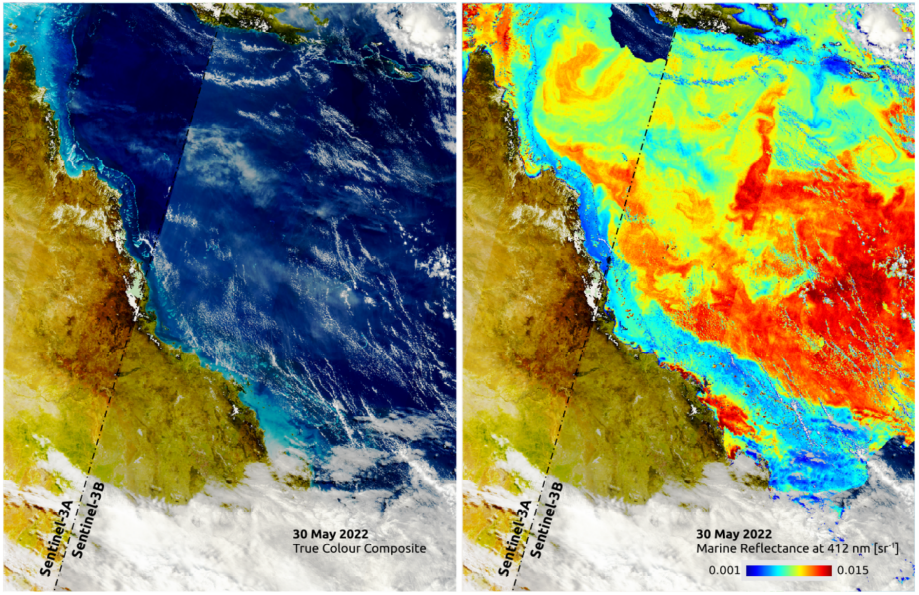
Figure 1: True colour composite acquired over the Great Barrier Reef by Sentinel-3 A/B OLCI on 30 May 2022 (left) and corresponding derived marine surface reflectance at a wavelength of 412 nm.
Application of Synthetic Aperture Radar (SAR)
Detection of oil discharges in marine waters from space using Synthetic Aperture Radar (SAR) satellite sensors satellite sensors has undeniably reduced their occurrence both in Europe (EMSA) and in the US (NOAA). A satellite-based monitoring service for oil spills or illegal oil discharges was not available in Australia until December 2021.
CSIRO under eReefs has developed, and deployed, a semi-automated oil slick monitoring and detection system specifically tailored to the Great Barrier Reef using the Sentinel-1A SAR satellite sensor. Empirical and machine learning techniques specifically tuned for the Great Barrier Reef (such as the presence of reefs, which resemble oil slicks in SAR imagery) allow for daily monitoring of the marine park and accurate reporting of possible oil-like features. The system is operated daily under for the monitoring of the Great Barrier Reef. The Sentinel-1 SAR scenes are automatically downloaded from the Copernicus Australasia Regional Data Hub and processed using a uniquely designed workflow.
Satellite remote sensing is without doubt the most adequate technology suited for the large-scale monitoring of the Great Barrier Reef, which covers 348,000 km2 (roughly equivalent to the size of Italy or Japan). The processing and detection workflow for the monitoring of the Great Barrier Reef is relocatable to other regions within Australia and elsewhere, such as Australia’s Northwest Shelf or Southeast Asia, where oil discharged from fixed oil and gas platforms or ships occurs regularly. When detections of oil slick features occur, a trained operator verify the information and may inform the relevant Australian agencies of possible incidents (Figure 2). Data access is provided through the eReefs Data Explorer.
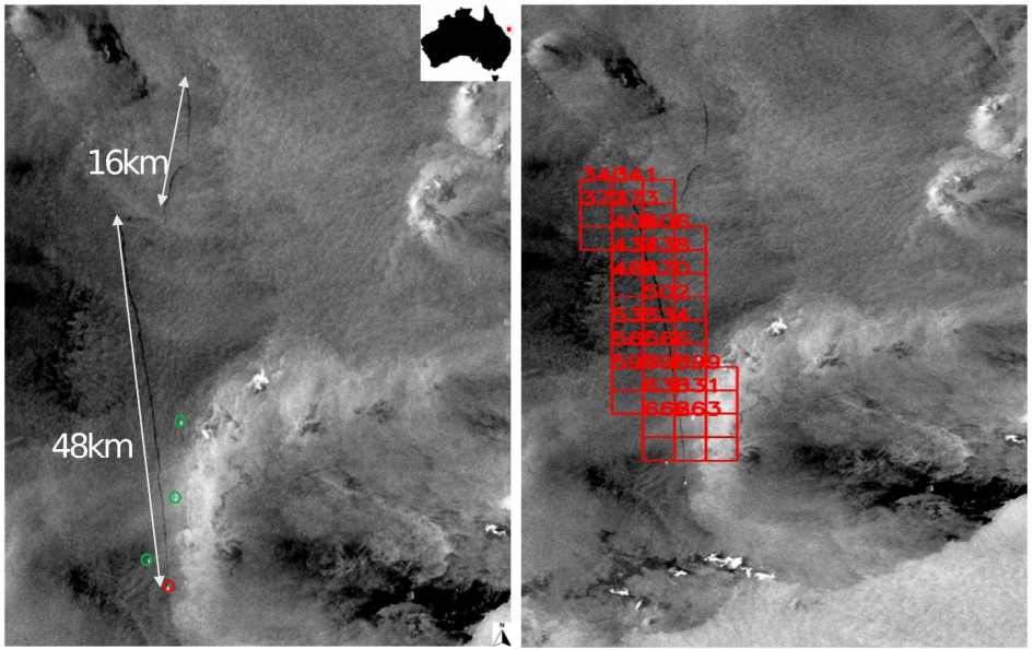
Figure 2: Left panel – the Sentinel-1A SAR scene acquired on 19th February 2023 showcasing a likely illegal discharge by a passing vessel (red circle) off Swain Reefs, Southern Great Barrier Reef, with other vessels nearby (green circles). Right panel – visualization of the automated detection (red squares) of the corresponding oil slick features by the CSIRO Environment Oil Spills detection system.