Ocean Observations and Dynamics
Ocean Processes Team, aboard CSIRO’s RV Investigator
Activity Leader: Dr Bernadette Sloyan
Staff and Associates:
Dr Chris Chapman
Dr Thomas Moore
Dr Amanda Black
Staff contact details are available on the Our People page
Ensemble forecasts are produced by integrating a climate model forward in time from a set of observation-based initial conditions and fundamental understanding of the dynamical processes in the ocean, ice and atmosphere that result in long-lived coherent variability in the climate system. Thus the observations and process understanding are part of the same activity, although there a strong links/crossover to all activities. The observation and process theme provided observational data for model initialisation, and used observations and models to identify key ocean-atmosphere processes that have the ability to drive multi-year coherent variability in the climate system
Observations
The technologies comprising ocean observing systems include a wide array of instruments and platforms (Figure 1). The heterogeneous nature of the ocean observing system requires a sophisticated data integration and interpretation activity for all available in situ and satellite observations. We provided integrated satellite and in situ observational data sets for initializing the forecasting system, providing withheld data sets and data products for model validation and, providing process resolving observations to inform model
physics assessments and improve the realism of our models.
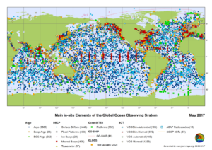
Figure 1. Main components of the Global Ocean Observing System (GOOS) that will provide in situ data to CAFE
for ocean initialization, validation, ocean process understanding.
Ocean Processes
As the forecast timescale increases (seasonal to decadal), processes in the ocean become increasingly more important. However, the generation of coherent ocean anomalies does not guarantee a skilful forecast. Knowledge of the dynamical processes that generate coherent long-lived ocean is key to understanding the potential predictability for the climate system.
We worked to identify key ocean processes that drive multi-year coherent variability in the ocean and assess what their impact was on climate variability and climate forecasting.
Ocean Storm Tracks
Connecting the slowly evolving ocean signals to the tropics and mid-latitudes and how these anomalous ocean signals re-emerge at the ocean-atmosphere boundary is a key challenge for seasonal to decadal climate forecasting. Discovering how the ocean drives the low frequency variability of the mid-latitude atmospheric circulation is still very much an open question, but of utmost importance is understanding droughts and climate extremes and in determining the predictability of the climate system.
Ocean-atmosphere-ice coupling
There remain many unanswered questions on the fundamental nature and drivers of the production of ocean variability with the potential for it to remain coherent on the multi-year to decadal time scale and how these anomalous ocean signals re-emerge at the ocean-atmosphere boundary. Our work investigated the dynamical ocean-atmosphere-ice-coupling to better understand the connection and feedback on the climate system.
View Transcript for Video Here
Big Data
The Decadal Climate Forecasting Project (DCFP) has embarked on building a “big data” climate science platform to address the opportunities and challenges in the large ensemble datasets generated by our models.
Given the explosive growth of these datasets it’s becoming increasingly impossible to interactively explore our climate model results and this is hindering scientific inquiry and discovery. The resulting fragmentation of workflow solutions renders most geoscience research effectively unreproducible and prone to error. Ultimately this “big data crisis” is not limited to the field of climate science. The solutions we are developing will almost certainly be directly applicable to CSIRO-wide data science challenges.
The vision, borrowed from Pangeo – a community platform for big data geoscience, is an interactive data exploration workflow that scales to meet our current and future challenges. The workflow is more open and reproducible, containerised and portable, and ultimately, collaborative. We have adopted a Pangeo-style approach and related python-based software stack that we’ve deployed on CSIRO HPC resources. The performance we have seen in our trials has been encouraging and also justifies the employment of CSIRO’s new parallel cluster file system, which is ideally suited for a scalable workflow.
Publications
| Bax, H.J; Ward Appletons, W; Brainard, Duffy; R. J. E; Dunstan, P; Hanich, Q; Harden Davies, H; Hills, J; Miloslavich, P; Muller-Karger, F; Simmons, S; Aburto-Oropeza, O; Batten, S; Benedetti-Cecchi, L; Checkley, D; Chiba, S; Fisher, A; Andersen Garcia, M; Gunn, J; Klein, E; Kudela, R; Marsac, F; Obura, D; Shin, Y-J; Sloyan, B; Tanhua, T; Wilkin, J; (2018) Linking capacity development to monitoring networks to achieve sustained ocean observation. Frontiers in Marine Science |
| Alford, M; Sloyan, B; Simmons, H; (2017) Internal waves in the East Australian Current. 44 12,280 – 12,288 Geophysical Research Letters https://doi.org/10.1002/2017GL075246 |
| Sloyan, B; Craw, P; King, E; Neill, C; Kloser, R; Bodrossy, L; (2017) Future Technologies in B. Mapstone (ed) Oceans: Science and solutions for Australia 179-186 http://www.publish.csiro.au/book/7724/ |
| Feng, M; Zhang, X; Sloyan, B; Chamberlain, M (2017) Contribution of the deep ocean to the centennial changes of the Indonesian Throughflow. 44 2859-2867 Geophysical Research Letters https://doi.org/10.1002/2017GL072577 |