3DPlus
3DPlus: Simultaneous LIDAR Mapping and Measurement
3DPlus is a 3D LIDAR system with additional sensing capability for realtime sampling, combined with CSIRO’s advanced Realtime Simultaneous Localisation and Mapping (SLAM) software. This combined allows low- cost, high resolution 3D sensing.
World Leaders in Mobile Lidar Mapping
Our world leading continuous- time SLAM software is at the core of mobile LIDAR Mapping devices such as ZEB-1, ZEB-REVO and SurphSLAM. 3DPlus is designed to provide the location sensed values along with the path followed, it uses the SLAM software to generate accurate 3D maps without using GPS.
3DPlus
The System consists of:
- A hand heled unit, which includes a scanning laser and rotation mechanism for the laser as well as a USB3 hub for sensors. It has been designed to mount USB sensing devise as close as possible to the centre point of the measured trajectory. This minimizes the offset if the sensed point from the nominal centreline of travel.
- A data logging computer in a small pack.
Map Generation
LIDAR data is logged and processed on-board and transferred off-board via WIFI after mapping. CSIRO SLAM algorithms are applied to the raw data to produce a trajectory(path followed), the location of the sensed phenomena and 3Dpoint cloud of the mapped environment, which is made available for download via WIFI from the logger.
Benefits
- No prior drawings are required before sensing/scanning, the map is generated as the sensed values are collected.
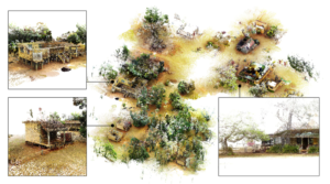
Map of trees using 3Dplus
- Self-contained mapping solution- handheld unit and small backpack.
- Spherical field of view- maps below, above and all around
- Individual maps can be fused together to generated a large map
Applications
- Generating acoustics, pas concentration or WI-FI maps of plants
- Readily adaptable to other near real time sensors