• CSIRO.au
CSIRO.au
Centre for Earth Observation
Skip to content Skip to search
  • About
  • News
  • EASI
  • Satellite Cal/Val
    • Pinnacles
    • AusCalVal
  • NovaSAR-1
    • About NovaSAR-1
    • NovaSAR-1 User Guide
    • Data access
    • Resources
    • Contact
  • SAR capability
  • Partnerships
  • Case Studies
  • CSIRO.au
  • floods

#floods

Smartsat CRC uses NovaSAR-1 and Sentinel-1 to revolutionise Australian flood management

Harnessing NovaSAR and Sentinel satellite imagery to revolutionise Australian flood management

NovaSAR-1 images regions affected by Ex-Tropical Cyclone Alfred and flooding

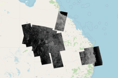
NovaSAR-1 images over flooded regions in 2025 overlaid on a map of Australia CSIRO acquired a number of images to […]

Sentinel-1 and NovaSAR-1 flood maps for the Lachlan Valley study site. Different colours represent a different date. The flood maps are overlaid on a Google Maps background.

Mapping flood events across Australia using NovaSAR-1 and Sentinel-1

Australia is prone to frequent and severe flooding events that cause significant damage to infrastructure, agriculture, and ecosystems. The challenge […]

At CSIRO, we solve the greatest challenges through innovative science and technology.

  • Connect with us on Facebook
  • Connect with us on Instagram
  • Connect with us on LinkedIn
  • Hear our our Spotify playlists
  • Threads
  • Watch our youtube videos

  • Access to information
  • Accessibility
  • Copyright
  • Legal notice and disclaimer
  • Policy & Guidelines
  • Your privacy

We are committed to child safety and to the implementation of Child Safe principles and procedures.

  • Contact us

Subscribe to CSIRO updates

  • Subscribe now

CSIRO acknowledges the Traditional Owners of the land, sea and waters, of the area that we live and work on across Australia. We acknowledge their continuing connection to their culture and pay our respects to their Elders past and present. View our vision towards reconciliation.