Synthetic Aperture Radar capability
Data from Synthetic Aperture Radar (SAR) Earth observation satellites is under-utilised in the Australian research ecosystem. CSIRO is investing in SAR infrastructure (though the NovaSAR-1 national facility) and undertaking applications research to raise awareness and demonstrate how SAR can be applied to challenges facing Australia and the world. We apply our SAR expertise to use NovaSAR-1 and other datasets to develop innovative research applications, define standards for Analysis Ready Data, and increase data uptake.
SAR applications research
We work with scientists from across CSIRO and partner organisations (such as Geoscience Australia and the Australian Antarctic Division) to apply SAR to applications including:
|
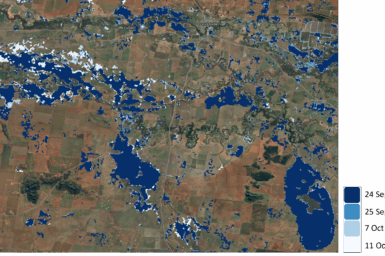
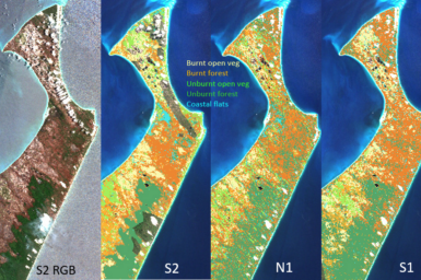
Flood and bushfire boundary mapping Crop type classification and paddock boundary detection Ground motion measurement for assessing groundwater usage and subsidence hazards Erosion and geomorphological assessments |
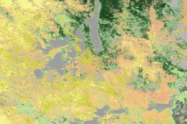
Ecosystem extent mapping and land-use classification Soil surface moisture Deriving ocean surface wind speeds Ship, vessel and oil slick detection Supporting calibration of SAR sensors and validation of SAR-derived products |
Examples
Analysis Ready Data for SAR
![]()
CSIRO has been a key contributor to the Committee on Earth Observation Satellites (CEOS) Analysis Ready Data (ARD) for SAR initiative.
In 2024, CSIRO’s NovaSAR-1 Normalised Radar Backscatter products were certified to be compliant with the CEOS ARD product family specifications. These products are delivered through the NovaSAR-1 datahub.
A Sentinel-1 Normalised Radar Backscatter pipeline has also been implemented for users of CSIRO’s Earth Analytics Science and Innovation platform (EASI); a scalable, cloud-based data analysis infrastructure to support large-scale research.