Application of S-band NovaSAR-1 to bushfires in Australia
The challenge
Bushfires are a major threat to lives, properties and ecosystems in Australia. They are influenced by various factors such as weather, fuel load, vegetation type and human activities. Accurate and timely information on fire location, extent, intensity and behaviour is essential for fire management and emergency response.
However, conventional optical and thermal sensors on satellites have limitations in detecting and monitoring bushfires, especially under cloudy or smoky conditions. Moreover, the revisit time and spatial resolution of these sensors may not meet the operational needs of fire agencies and stakeholders. As demonstrated below, heavy cloud cover occurs in this region, particularly during the southern hemisphere summer months, and thus emphasizes the value of using SAR data for assessing bushfires and other applications in northern Australia.
We applied syntheric aperture radar (SAR) data from the NovaSAR-1 satellite (acquired as part of Australia’s capacity share operated by CSIRO) to carry out a first S-band assessment of three bushfires during first 12 months of NovaSAR-1 operations: close to Jervis Bay, New South Wales (December 2019 – January 2020); at Tumbarumba, New South Wales (January 2020) and on World Heritage Listed K’gari (Fraser Island), Queensland (October – December 2020).
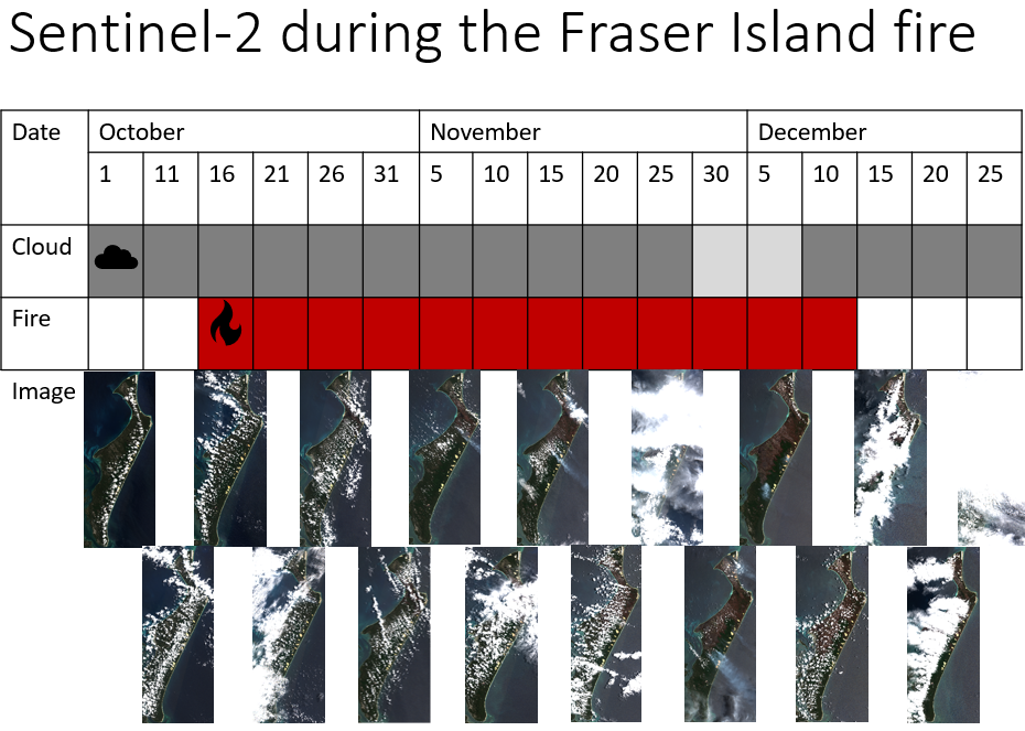
Sentinel-2 cloud cover during the Fraser Island fire
The opportunity
NovaSAR-1 is a novel synthetic aperture radar (SAR) satellite launched in 2018 by Surrey Satellite Technology Ltd (SSTL), a UK-based company. It operates at S-band frequency, which has the advantage of penetrating clouds, smoke and vegetation canopy, and providing 24/7 imaging capability. It also offers a range of imaging modes and incidence angles, which can enhance the detection and characterisation of different types of targets and phenomena.
The potential to increase the use of SAR data for hazard monitoring purposes in Australia has been recognised, for example by the Bushfire Earth Observation Taskforce. This taskforce was launched by the Australian Space Agency as part of the Royal Commission into Natural Disaster Arrangements following devastating bushfires at the beginning of 2020. The taskforce noted that:
Australia has increasing access to data from several SAR
Bushfire Earth Observation Taskforce Report https://naturaldisaster.royalcommission.gov.au/system/files/exhibit
satellites… but their capability to see through clouds and
smoke for bushfire support is still to be developed and that
it would be useful for Australian research agencies and fire
services to develop the use of… SAR… for this purpose
/IND.0003.0001.0001.pdf
The project
In 2019-2020, Australia experienced one of the most devastating bushfire seasons on record, which burned more than 18 million hectares of land, destroyed over 3000 homes, and killed at least 34 people and more than one billion animals.
The fire on World Heritage listed Fraser Island burned for approximately 2-months between October and late December 2020. The extent of the fire, which burned over half of the island, can be observed in the Sentinel-2 validation image.
CSIRO conducted a project to demonstrate the feasibility and utility of S-Band Novasar-1 data for mapping and measuring the impacts of bushfires across different regions and ecosystems in Australia.
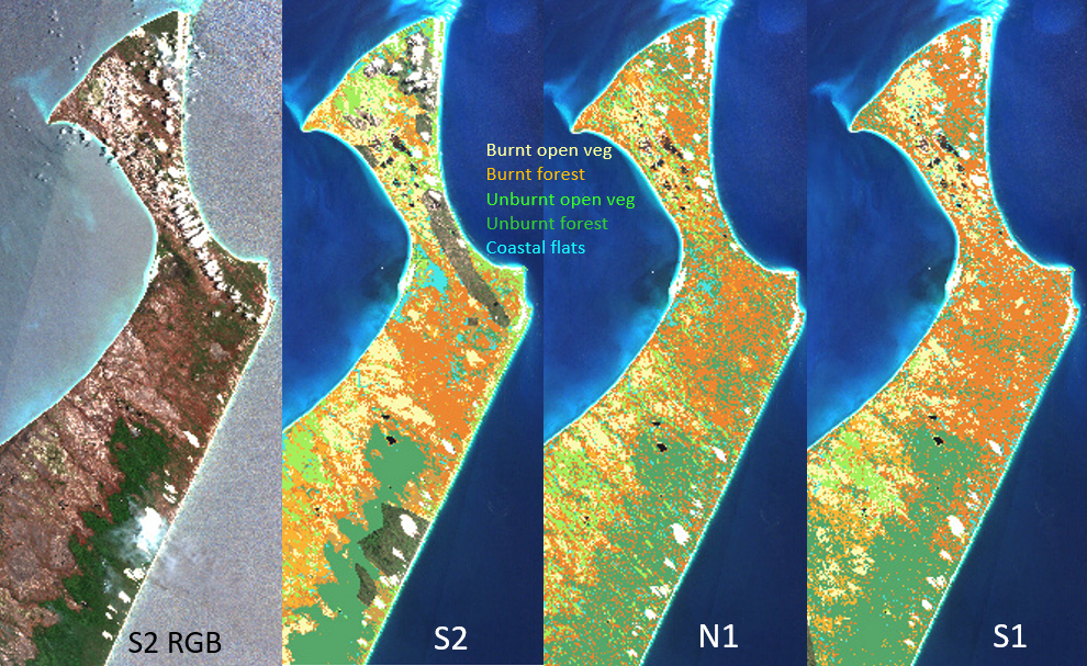
By using complimentary imagery from C-band Sentinel-1, we carried out the first comparison between C- and S-band SAR for burnt area mapping applications, validating the observation with Sentinel-2 multi-spectral imagery in the absence of ground-truth data.
Outcomes
Initial observations from NovaSAR-1 demonstrate the potential of these data for assessing bushfire impacts. Limitations, such as the absence of pre-fire imagery, have now been resolved, with baseline imagery now acquired over the whole Australian landmass.
Read the paper here: 10.1109/IGARSS47720.2021.9554209