Groundwater Modelling
Groundwater is a critical resource for irrigators and town water suppliers, accounting for nearly a third of the water used in Australia. Data61 is developing tools and techniques to improve the understanding of how groundwater flows and how it may respond to varying usage scenarios.
Project Background
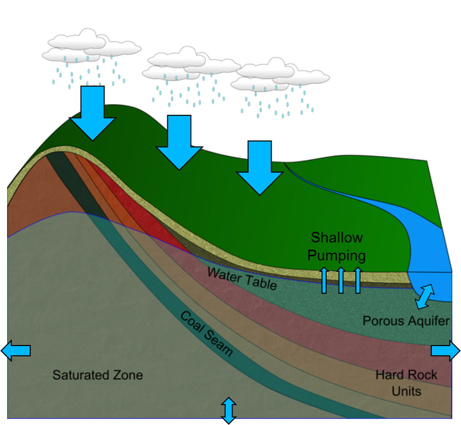
Groundwater, which exists under the surface of the earth in geological structures, is pumped out as part of the coal seam gas extraction process to allow the gas to move more freely. Large coal mine developments may also impact the existing flow regimes of groundwater systems. As with most underground environments, there is often sparse information about the system’s characteristics and this introduces the potential for uncertainty in what the future effects of extracting water will be on the environment and other water users.
Data61’s unique approach
Data61 is developing new tools and techniques to help modellers and assessors understand a groundwater system and aid in the quantification of uncertainty in predictions made for how it will behave in the future. This is occurring in four complementary areas.
1. Groundwater exploration and visualisation tool:
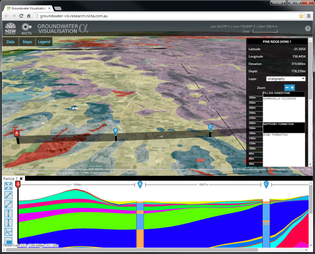
The groundwater visualisation and data exploration system is a web based visualisation tool and data portal that provides a user with a quick and easy method of exploring, comparing and visualising 3D geological and hydrogeological models, and other supporting data from authoritative government agencies and third parties.
(also link to youtube video)
2. Small scale hydrogeological modelling and uncertainty quantification tool:
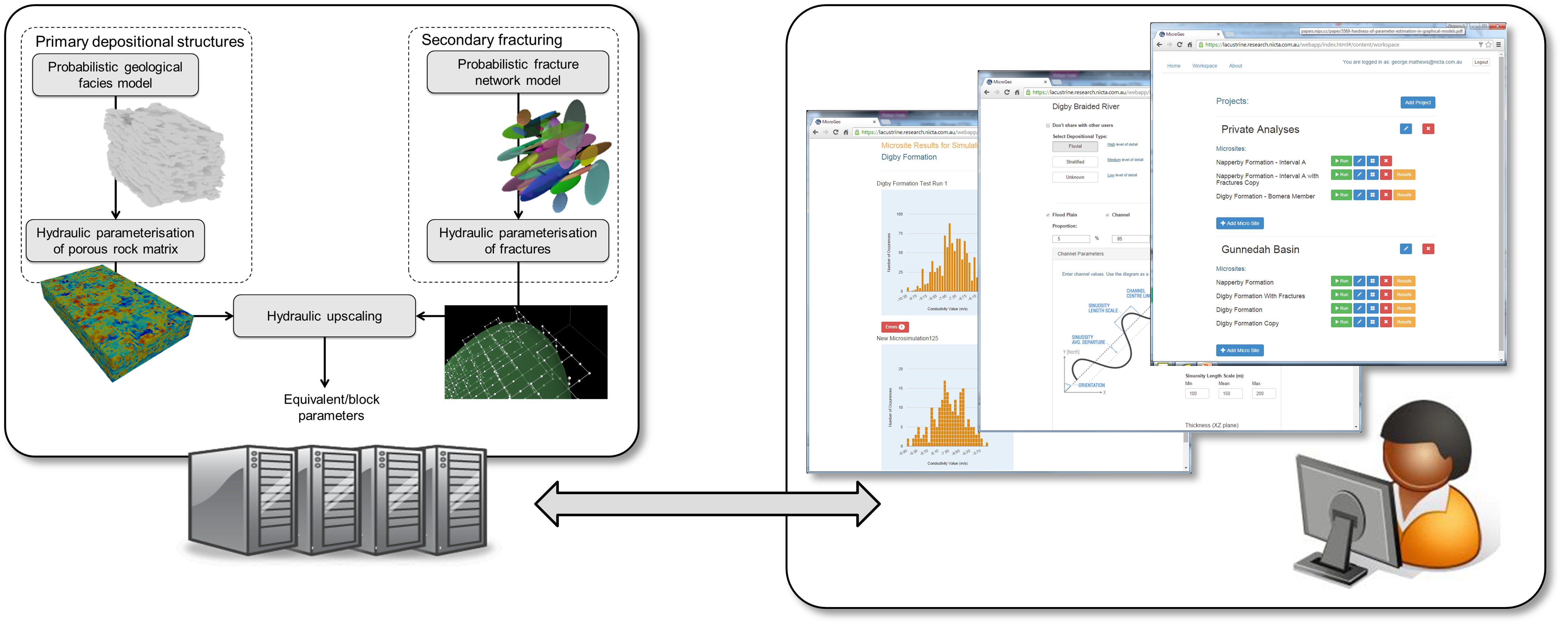
This system helps quantify the uncertainty in the important effective hydraulic conductivity parameters within a groundwater flow model using small scale observations acquired from borehole geology logs, core samples and geophysics data, and knowledge of the depositional history of a basin. This is critical for predictions that are heavily dependent on the subsurface’s conductivity properties but where there is limited water level and flow measurements that provide poor constraints on these important properties. The system is a web based software tool that allows probabilistic analyses to be performed on a server side compute cluster.
3. Inference and prediction with probabilistic dynamics models:
This is a new stochastic groundwater simulation system that allows potential errors to be represented directly in the temporal dynamics of the groundwater flow system. This allows errors that arise from model simplifications and other unknown sources to be captured. This modelling framework has been combined with new inference (or calibration) and prediction algorithms to allow the uncertainties to be estimated and propagated into the future to generate impact predictions, along with an estimate of their uncertainty.
4. Uncertainty quantification with simplified models and limited data:
This research is providing new insight into how modelling simplifications to complex systems affect the ability to extract information from data, combine it with expert knowledge and finally propagate it to predictions of interest. The objective here is to understand the conditions that allow consistent measures of uncertainty to be generated for the predictions of interest, when simplified models are used.
Collaborators
![]()
![]()
Download the Groundwater Impact Assessment brochure.