News | What lies beneath? A new technique to uncover the Australian continent
Learn about the new workflow that gives a more detailed deep earth model of Australia and what this means for resource targeting.
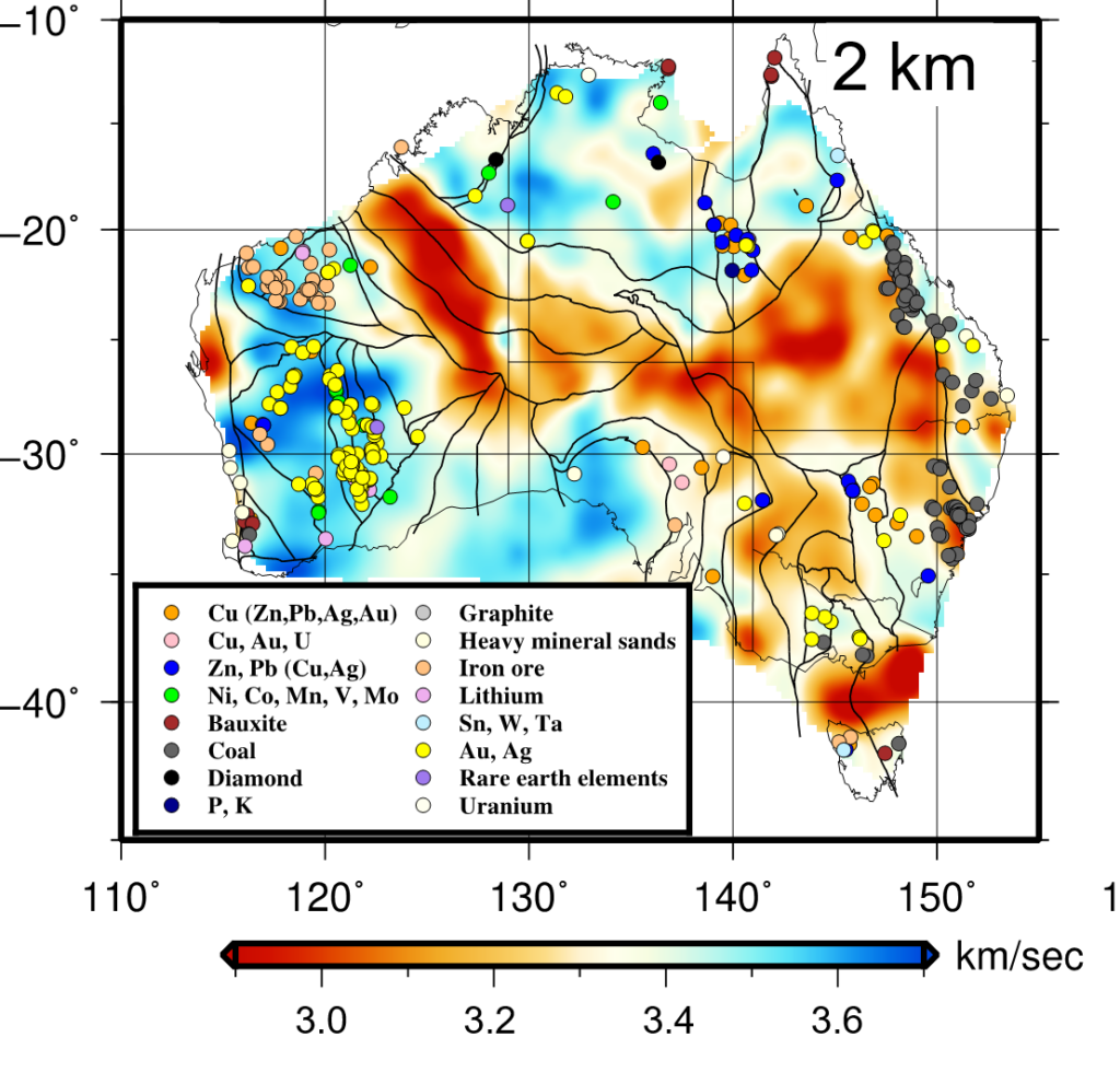
Figure 1. The locations of operating mines in Australia superimposed on a map of the shear velocities at 2 km depth across Australia to show the relationship between the variation of the Earth’s composition at depth and known mineral resources (results from Yunfeng’s work).
In the bid to find new exploration resource targets across Australia a key question stands: How can we “see” through the surface sedimentary rock cover to map the deep, underlying rocks?
Thick surficial layers of rock (regolith and sedimentary basins) cover approximately 80 per cent of the Australian continent – vast swathes of land with great potential to host mineral resources – yet these complex coverings make exploring for what lies beneath them a major challenge. Australia’s future economic prosperity is dependent on discoveries of world-class mineral resources, and to achieve this an advanced exploration approach is needed; one that looks for deep mineral deposits.
Yunfeng Chen, one of the Deep Earth Imaging FSP former postdocs (now a CSIRO Research Affiliate and Assistant Professor at the Zhejiang University), has been researching a specialised, deep earth imaging method to better understand the sedimentary basins present across Australia.
Yunfeng and his team have developed a sophisticated workflow to integrate a large amount of data recorded by seismic sensors positioned across the continent over the past 25 years. Until now, such a task has been impossible. The workflow is sensitive to depths of 50 km and extracts significantly more subsurface information – 2 to 3 times more – than conventional methods, although these are still useful for looking at intricate subsurface features.
The method has been used to build a new, more detailed deep earth model of Australia. It offers fresh insights into the complex nature of the continent’s sedimentary basins; information that is critical in the search for new resources. This cutting-edge tool presents an exciting advance in resource exploration technology, one that looks set to help Australia’s explorers in their efforts to discover new, deep mineral deposits.
To find out more you can read the paper; Empirical Green’s Function Retrieval Using Ambient Noise Source-Receiver Interferometry, recently published in the Journal of Geophysical Research Solid Earth.