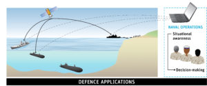
Defence applications of regional modelling
The Royal Australian Navy operates in a complex environment, including ocean surface, the subsurface, and the atmosphere. Understanding that environment is critical to operational success.
CSIRO
Tactical environment for the application of ROAM data
ROAM enables an operator to configure an ocean, atmospheric, and/or wave model for any region around Australia to produce a hindcast over any time period, or a forecast.
The outputs provide Defence guidance on:
- The density of the ocean, which depends on temperature, salinity and depth, influences how sound propagates. Density layers and other ocean structures, such as eddies and temperature fronts, therefore affect the detectability of both surface vessels and submarines by sound, either passively just by listening, or actively using sonar. By understanding the 3D sound environment the Navy can gain tactical advantage through knowledge of where their submarines can be hidden from, or detected by, surface ships. Navy ships can similarly determine when and where they can expect to detect submarines. They can manage risk by awareness of their “blind-spots” understanding their uncertainty.
- Safely navigating a submarine away from the surface for extended periods to avoid detection requires an understanding of the submarine’s speed and direction. Submarines have no underwater GPS so knowledge of the impact of ocean currents that may “push” the submarine off course is critical for both safety and mission completion.
- Weather conditions play a key role in radar propagation and the surface wave environment. The ability of a ship to detect approaching vessels by radar, depends on the weather. Some conditions make detection over long-distances possible – while other conditions make it impossible and the difference is important in planning and execution of operations.
- Wave conditions are important for manoeuvring small vessels. Forecasts of wave conditions enable planning for safe and successful operations several days ahead of time.
- Landing operations, with amphibious vessels, or via parachute, are also critically dependent on weather. High resolution forecasts of winds and waves in the littoral zone provide knowledge of rip currents, surf conditions, the presence of sand bars and the impact of land topography on the wind.
All these capabilities are provided by Bluelink to enable the Navy to plan and manage their operations with greater certainty and less risk – and are intended to provide the Navy with a tactical advantage over their adversaries.
Commonwealth of Australia
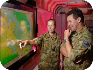
Defence personnel access ocean model output © Commonwealth of Australia